| Height: | Elevation: | 339 ft (103 m) | GPS Latitude: | 41.79019 | ||
| Volume: | 23,000 ft3 | (651 m3) | Creek: | Jordan Creek | GPS Longitude: | -124.13698 |
| Width: | 22.50 ft | (6.86 m) | Grove: | National Tribute Grove | Discovery Date: | |
| Age: | Park: | Jedediah Smith Redwoods SP | Discovered By: |
Notes: Church Tree contains a fire-hollowed chamber which measures 20 ft (6 m) across and 43 ft (13 m) tall. Local residents have camped and even held wedding ceremonies inside this tree.
Drive: Church Tree is 292 mi (470 km) north of San Francisco near Crescent City.
Northbound: From U.S. Highway 101, 5 mi (8 km) north of Crescent City, take exit 794 to merge onto U.S. Highway 199 and turn right onto Elk Valley Cross Road. Drive southeast 0.2 mi (0.3 km) on Elk Valley Cross Road and turn right onto Elk Valley Road.
Southbound: From U.S. Highway 101, 5 mi (8 km) north of Crescent City, turn left onto Elk Valley Cross Road. Drive southeast 0.6 mi (1.0 km) on Elk Valley Cross Road and turn right onto Elk Valley Road.
Drive south 0.7 mi (1.1 km) on Elk Valley Road and turn left onto Church Tree Road. Drive east 0.6 mi (1.0 km) on Church Tree Road and park at a turnout on the left/east side of the road near 41.79116 -124.13719.
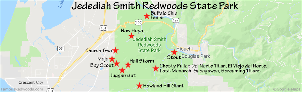
Hike: GPS-assisted navigation is recommended for this hike. From the turnout, hike south 370 ft (113 m) off-trail to Church Tree.
| Rating: | Easy | One-Way Distance: | 370 | (113 m) | Ascent: | 25 ft | (8 m) |
| Time: | 5 min | Off-Trail: | 370 ft | (113 m) | Descent: | 0 ft | (0 m) |

View Church Tree location in Google Maps
Panorama: Click panorama to take a virtual tour of Church Tree

Photos: Pictures of Church Tree taken from different sides


