| Height: | 361.29+ ft | (110.12+ m) | Elevation: | 255 ft (78 m) | GPS Latitude: | 40.29559 |
| Volume: | Creek: | Canoe Creek | GPS Longitude: | -123.90531 | ||
| Width: | 10.80 ft | (3.29 m) | Grove: | Garden Club of America Grove | Discovery Date: | |
| Age: | Park: | Humboldt Redwoods SP | Discovered By: |
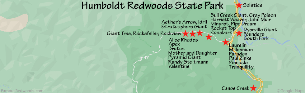
Notes: Canoe Creek is the 27th tallest tree in Humboldt Redwoods State Park and the tallest tree in Garden Club of America Grove.
Drive: Canoe Creek is 191 mi (307 km) north of San Francisco near the community of Weott.
Northbound: From U.S. Highway 101, take Exit 656 Myers Flat and turn right onto California State Route 254 (Avenue of the Giants). Drive north 2.5 mi (4.0 km) on California State Route 254 (Avenue of the Giants) and turn left at the entrance to Garden Club of America Grove Day Use Area.
Southbound: From U.S. Highway 101, take Exit 661 Weott, and turn right onto Newton Road. Drive west 0.4 mi (0.6 km) on Newton Road and veer left onto Lum Street. Drive west 400 ft (122 m) on Lum St and turn left onto California State Route 254 (Avenue of the Giants). Drive south 3.5 mi (5.6 km) on California State Route 254 (Avenue of the Giants) and turn right at the entrance to Garden Club of America Grove Day Use Area.
Drive west 0.1 mi (0.2 km) on the unnamed road to the Garden Club Grove of America Day Use Area parking lot.
Hike: GPS-assisted navigation is recommended for this hike. From the trailhead at the western edge of the parking lot, hike west 0.1 mi (0.2 km) toward South Fork Eel River. Turn left at the riverbed and hike south 200 ft (61 m) to the seasonal footbridge over South Fork Eel River. Cross the seasonal footbridge and hike west 0.1 mi (0.2 km) to the junction with River Trail. Turn right at the trail junction and hike north 0.8 mi (1.3 km) on River Trail, across Canoe Creek, to the trail exit point near 40.29676 -123.90553. Leave the trail here and, using a GPS device, hike south 0.1 mi (0.2 km) to Canoe Creek.
River Warning: Canoe Creek is not accessible from the Garden Club of America Grove Day Use Area parking lot when South Fork Eel River has high water levels and the seasonal footbridge is not installed. It is best to visit Canoe Creek from July through October when South Fork Eel River is low enough to wade across.
| Rating: | Moderate | One-Way Distance: | 1.1 mi | (1.8 km) | Ascent: | 279 ft | (85 m) |
| Time: | 40 min | Off-Trail: | 0.1 mi | (0.2 km) | Descent: | 212 ft | (65 m) |

View Canoe Creek Tree location in Google Maps
Panorama: Click panorama to take a virtual tour of Canoe Creek Tree

Photos: Pictures of Canoe Creek Tree taken from different sides


